| URL | http://<rastercatalogitem-url>/image |
|---|---|
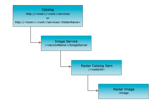
| Parent Resource | Raster Catalog Item |
| Required Capability | Image,Catalog |
Description
The raster image resource returns a composite image for a single raster catalog item. Users can use this resource for generating dynamic images based on a single catalog item.
This resource provides information about the exported image, such as its URL, its width and height, and extent.
Apart from the usual response formats of html and json, users can also request a format called image for the image.
When users specifies the format of image, the server responds by directly streaming the image bytes to the client.
With this approach you don't get any information associated with the image besides the actual image.
Resource Hierarchy
Parameters
| Parameter | Details |
|---|---|
| f |
Description: The response format.
The default response format is html. If the format is
image, the image bytes are directly streamed to the
client.Values: html | json | image |
| bbox |
Description: The extent (bounding
box) of the exported image. Unless the bboxSR parameter
has been specified, the bbox is assumed to be in the
spatial reference of the image service.Syntax: <xmin>, <ymin>, <xmax>, <ymax>
Example: bbox=-104,35.6,-94.32,41
The bboxcoordinates should always use a period as
the decimal separator even in countries where traditionally a comma
is used.
|
| size | Description: The size (width *
height) of the exported image in pixels. If the size is
not specified, an image with a default size of 400 * 400 will be
exported.Syntax: <width>,
<height>Example: size=600,550 |
| imageSR |
Description: The spatial reference of the exported image.
The spatial reference can be specified as either a well-known ID or as a spatial reference json object. If the imageSR is not specified, the
image will be exported in the spatial reference of the image service. |
| bboxSR |
Description: The spatial reference of the bbox.
The spatial reference can be specified as either a well-known ID or as a spatial reference json object. If the bboxSR is not specified, the
bbox is assumed to be in
the spatial reference of the image service. |
| format | Description: The format of the
exported image. The default format is png. Values: png | png8 | png24 | jpg | bmp | gif |
| pixelType | The pixel type, also known as data type, pertains to the type of values stored in the raster, such as signed integer, unsigned integer, or floating point. Integers are whole numbers, whereas floating points have decimals. Values: C128 | C64 | F32 | F64 | S16 | S32 | S8 | U1 | U16 | U2 | U32 | U4 | U8 | UNKNOWN |
| noData | The pixel value representing no information. Example: noData=0 |
| interpolation | The resampling process of extrapolating the pixel values while transforming the raster dataset when it undergoes warping or when it changes coordinate space. Values: RSP_BilinearInterpolation | RSP_CubicConvolution | RSP_Majority | RSP_NearestNeighbor |
| compressionQuality | Controls how much loss the image will be subjected to by the compression algorithm. Valid value ranges of compression quality are from 0 to 100. Example: compressionQuality=75 |
Example Usage
Example 1: Return Raster Image (f=html) for raster ID 8.
http://sampleserver3.arcgisonline.com/ArcGIS/rest/services/Portland/CascadeLandsat/ImageServer/8/image?bbox=378501.375,4825171.125,634687.875,5051974.125&bandIds=0,1,2Example 2: Return Raster Image (f=image) for raster ID 8 in png8 format.
http://sampleserver3.arcgisonline.com/ArcGIS/rest/services/Portland/CascadeLandsat/ImageServer/8/image?bbox=378501.375,4825171.125,634687.875,5051974.125&bandIds=0,1,2&f=image&format=png8JSON Response Syntax
{
"href" : "<href>",
"width" : <width>,
"height" : <height>,
"extent" : <envelope>
}
JSON Response Example
{
  "href" : "http://sampleserver3a.arcgisonline.com/arcgisoutput/_ags_336971124.png",
  "width" : 400,
  "height" : 400,
  "extent" : {
    "xmin" : 7585040,
    "ymin" : 695086,
    "xmax" : 7590710,
    "ymax" : 700756,
    "spatialReference" : {
      "wkt" : "PROJCS[\"NAD_1983_HARN_StatePlane_Oregon_North_FIPS_3601\",GEOGCS[\"GCS_North_American_1983_HARN\",DATUM[\"D_unknown\",SPHEROID[\"North_American_1983_HARN\",6378137.0,298.257222101]],PRIMEM[\"Greenwich\",0.0],UNIT[\"Degree\",0.0174532925199433]],PROJECTION[\"Lambert_Conformal_Conic\"],PARAMETER[\"false_easting\",8202099.737532808],PARAMETER[\"false_northing\",0.0],PARAMETER[\"central_meridian\",-120.5],PARAMETER[\"standard_parallel_1\",44.33333333333334],PARAMETER[\"standard_parallel_2\",46.0],PARAMETER[\"latitude_of_origin\",43.66666666666666],UNIT[\"Foot\",0.3048]]"
    }
  },
  "scale" : 0
}